 TERRITORY |
LOCATION
TERRITORY |
LOCATION
COME AND SEE THE TERRITORY AND MUCH MORE INFORMATION ABOUT OUR GEOPARK!
GEOPARK TERRAS DE CAVALEIROS
The territory of the Terras de Cavaleiros Geopark is located in the heart of the Trás-os-Montes plateau, with dominant altitudes between 400m and 800m, with Serra de Nogueira (1320m) to the north, Ala (844m) and Cubo (844m) in the center ( 777m), to the south the Serra de Bornes (1199 m) and, to the east, the Monte de Morais (750m), a region of transition from the plateau Cold Land to the Hot Land of Tua and Douro Superior, where winters and summers occur with intermediate characteristics.
For the most part, the municipality does not have the mountain character and harsh climate of Terra Fria, but it also does not reach the high temperatures of Terra Quente. This region has long winters and short, hot summers, with frosts occurring from October to May (Mendes, 2005).
The Terras de Cavaleiros Geopark is a well-defined geographical area, coinciding with the administrative limits of the Municipality of Macedo de Cavaleiros, with an important geological heritage to which is added a great biodiversity heritage, a notable historical-cultural heritage, local products, the rich gastronomy and the art of welcoming its people.
The unique Geological Heritage gives the opportunity to go through millions of years in the Earth's history, arousing the interest of geologists from all over the world. The Natural Heritage is different, with stunning and preserved landscapes, keeping alive the identity of the people, who preserve the secret of treating the land, the mastery with which they prepare their dishes and the affection with which they welcome those who visit them.
The Terras de Cavaleiros Geopark takes a proactive role in encouraging tourists to live rewarding experiences, which make them become an active protagonist and not a mere observer of the landscape. It contributes to the affirmation of this as a geotourist destination of excellence, which provides scientific, educational and cultural experiences, where all aspects of this approach contribute to the sustainable development of the territory, keeping its natural characteristics and the authenticity of its people intact.

GEOLOGY GEOPARK TERRAS DE CAVALEIROS
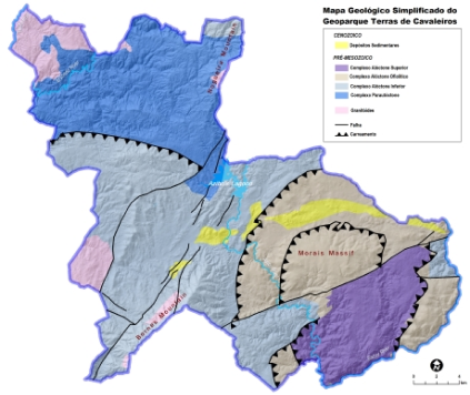
GEOLOGY | MASSIVE OF MORAIS
The territory of Geopark Terras de Cavaleiros contains a geological heritage of national and international relevance. A territory where its rocks tell stories millions of years old!
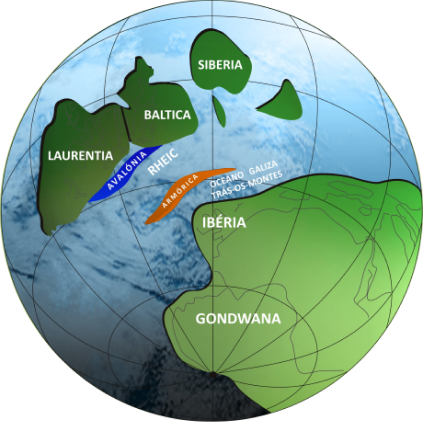
The geology of this territory takes us back to 540 Ma (millions of years), when the Variscan Cycle began. This cycle began with the breakup of a supercontinent and the opening of an ocean. This ocean, which was called Rheic, accumulated, throughout its existence, sediments from the erosion of the continents that bordered it. However, as the oceans are ephemeral, they end up closing when they reach their expansion limit. This cycle thus ended with the collision of all existing continents, leading to the formation of the great Variscan mountain chain, built between the Devonian-Carboniferous periods (380-280 Ma). This new mountain range thus encompasses the testimonies of the continents involved in this process, as well as the ocean that bordered them. With the collision of all existing continents around 250 Ma, the supercontinent Pangea was formed, which would later break up to give way to the current continents.
In the Morais Massif it is possible to find evidence (materialized by rocks) of this clash between continents and the consequent formation of the Variscan mountain chain, a rarity on planet Earth.
The Vilariça fault, which develops between Bragança, Vilariça and Manteigas, corresponds to a major tectonic accident, with a length of 250 km. This fault, although with low seismic activity, was once responsible for the 1858 earthquake, which destroyed the town of Moncorvo.
Associated with the movement of the fault, there was the uplift of blocks (in a push-up type model) such as the Serras de Bornes (1199 m) and the Serra da Nogueira (1320 m) and the subsidence of others, such as the depressions of Santa Combinha, Macedo de Cavaleiros or Vilariça.
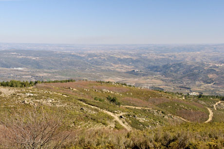
Monte de Morais appears as a flat relief, at around 750 m altitude, and represents part of the Fundamental Surface of the North Meseta (Surface resulting from the destruction of the Varisca mountain range).
INTERACTIVE MAP OF THE TERRAS DE CAVALEIROS GEOPARK
FOLLOW US ON SOCIAL MEDIA
